Sumba Island is one of the fastest developing islands in Indonesia. It has two airports and extensive new roads construction. The Island has some of the greatest surfing and scuba diving locations in the world. Sumba has an incredible diverse and unspoiled nature. In the past years price of land was increasing by 100% every year.

18 Mar
1
Sumba Island – Lesser Sundas – Indonesia
The island was first documented by Pigafetta, a travelling companion to famed Portuguese explorer Megellan in 1522, when the first ships of the Portuguese arrived on the isolated and tribal shores of Sumba.
They recorded proud natives clad in fine woven Ikats, their bodies adorned with beautiful ornaments, and wrote of the traditional villages perched on green hills and valleys swarming with sculptured stone megalithic tombs.
This unique island is referred to as the rising star of Indonesia. Arguably, this is the most attractive location in Asia in terms of opportunities for future tourism development and growth.
Sumba is located just one hour flight from the famous Bali, in the eastern part of Indonesia, and belongs to the Lesser Sunda islands, the Eastern Nusa Tenggara Province, Indonesia.
At that time the air was filled with the sweet-smelling aroma of sandalwood forests that covered the island and remained centuries later a highly sought after commodity earning its name as ‘Sandalwood Island’ with the Dutch colonisation in 1756.
The Sumbanese also bartered their sturdy horses for gold, silver and Chinese ceramics that were, and still are, highly regarded as precious items by the islanders.
Sumba was known amongst foreign traders as being an island of fierce warriors where headhunting expeditions were common. It was due to these incessant raids that the villages were built on hilltops and heavily fortified by stone walls.
The dry season was the period of the headhunting expeditions as well as the wars between rival clans and villages. In East Sumba, heads were used as tokens of territorial conquest in battles between nobles. In West Sumba, headhunting rites were often acts of revenge between equals. In both parts of the island the heads were considered trophies that would be displayed on “skull trees” in the villages. It was believed that the trophies brought home would stimulate prosperity and fertility of the village and the fields.
Since Indonesian Independence in 1945, Sumba has been part of Nusa Tenggara Timor, the “Southeastern Islands,” with its administrative capital in Kupang on the Island of Timor. Although the government has recently improved the cross-island road as well as ferry and airport access to the island, outside of the local administrative capitals of Waingapu and Waikabubak life has changed little.
Sumba is part of the Lesser Sunda Islands and its geography spans 11,000 square kilometres, making it twice the size of Bali, with only 650,000 inhabitants (approximately one sixth of Bali) where the majority of the population still follow the ways of their ancestors.
The terrain on Sumba is quite different to its neighbouring islands; undulating hills replace the typical volcanic terrain in Indonesia with many areas in the North and East of the island resembling dry savannahs, whilst central highlands are covered in native Alang Alang grass and the mountains in the South extend down into lush tropical vegetation.
The World Wildlife Fund categorised Sumba as a deciduous forest eco region due to its special flora and fauna. However, only 7% of the island’s forest remains protected and preserved. Laiwangi Wanggameti National Park and Manupeu Tanah Daru National Park were designated in 1988 to protect the nature.
Due to the isolated location of the island, the language, religion and traditional lifestyle of the Sumbanese culture has been preserved.
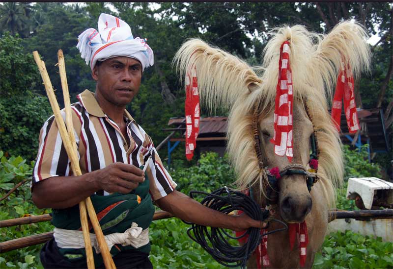
Traditional dress is still observed in day to day life; men wear a short sarong (Hinggi) around their hips with belt and sword and a band or turban of woven Ikat with motifs and women wear long sarongs and headbands with different motifs.
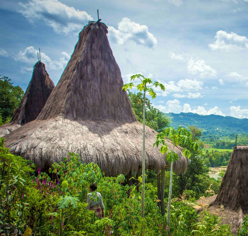
Traditional villages and settlements are commonplace with traditional houses constructed over three storeys in a wooden structure, high pointed roofs made from native Alang Alang grass and sides of plaited bamboo. The construction of a house is accompanied by rituals and is believed to be a social and ceremonial unit.
Throughout the year the island is the site of many fascinating rituals; the most spectacular of them all are the Pasola ceremonies that take place during the months of February and March at select locations along the west coast.
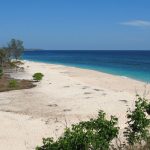
The island is covered with tropical jungles, emerald lakes and magnificent pristine bays with aquamarine colored ocean touching fantastic white sand beaches.
The island is ideal for all kinds of recreation activities: surfing, diving, snorkeling, jungle trecking, ocean, lake and river fishing, canoing, sailing and horse riding.
Sumba is not just about some of the best beaches in Indonesia and the world, it also offers many other fascinating and diverse religion and culture. It is only majority Christian island in Indonesia. It is also home to the ancient tribal traditions that were preserved over many centuries and can now be seen nowhere else.
Natural properties of the island are second to none amongst all the islands of Indonesia. Green savanna areas in the humid southern regions and limestone hills in the north, where the climate tends to be more dry. It’s south is famous for surfing, the north for diving, whereas the central region is where the cultural and religious heritage is located with villages offering an insight into the everyday life and unique tribal traditions of the native population. This rich diversity making every visitor to fall deeply in love with Sumba.
The island offers ideal waves for beginner and professional surfers alike, whereas those keen on diving can enjoy numerous sites with crystal clear water, rich corals and an amazing marine life of the ocean.
Today, Sumba is undergoing the construction boom. Real estate and infrastructure projects including new international hotels, two airports and the orbital motorway around the entire island, which will extend the accessibility to all unique scenic beaches of the island. Today Sumba enjoys the continuously growing influx of investments and new tourists both from Indonesia and abroad.
Ikat Weaving:
Ikat weaving throughout Sumba has social, religious and traditions of significance. Without expectation, is always as female task. The word “Ikat” itself means knotting or binding. The pattern that is required on the cloth is knotted and bound into the wrap yarn and the thread is dyed before weaving.During the process of making an Ikat textile, it is strictly taboo for men to see or be close to the dye bath; older woman will build or find an isolated spot and prepared the dye in secret.
Each district in this regency has its own distinctive design and shade. All reflected the life, culture and history of the island. It’s not a merely cloth but has a deeply meaning in their social and ceremonial when someone died.


22 Jan
0
How To Get To Sumba Island Indonesia
For international flights, you will need to travel via Bali’s Ngurah Rai International Airport in Denpasar. There are regular flights with Garuda Indoensia although most of them depart in the morning, thus an overnight stay in Bali is often required for international travellers.
Three airlines fly to Tambolaka airport, daily. To avoid spending the night in Bali, both the Singapore Airlines and Malaysia Airlines morning flights, allow you to connect on the 1pm Garuda flight.
All foreign travelers to Indonesia need at least six months remaining on their passport as well as one full clean page for the visa on arrival stamp. Guests will be denied access to board the plane in departing country if this is not adhered to.
Merpati and Batavia are bankrupt; TransNusa reduced their flights since October 2015 and cancelled all flights to Sumba. So there are 3 airlines that fly to Sumba regularly. Garuda flies daily the route Denpasar Tambolaka Kupang while Lion Air = Wings Air flies the route Denpasar Waingapu Lombok. Srivijaya Air = Nam Air flies daily the route Denpasar Waingapu Maumere Kupang, while Lion Air = Wings Air flies Denpasar Waingapu Kupang. If TransNusa = Trigana = Aviastar comes back to business, they will probably fly 3 times the week Denpasar Tambolaka Ende Kupang.
By now flight schedules are usually respected. Only if there are too few passengers, flights could be cancelled. However due to the amount of stops throughout the day, there will be delays. Only during monsoon and during strong winds, they will not fly.
Garuda flies with modern slim planes. It may happen that not all the baggage gets in. With Wings you have to pay extra for more than 10 kg of luggage…
Online bookings with these airlines often do not work. So the airlines’ websites presented on my link site are for information only. If you don’t want to wait too long in Bali, Lombok or Kupang, you must pre-book through a travel agency or via the most comfortable and safest way with Ticketindonesia from home on the internet. This is sometimes cheaper than via search engines. For Pasola or holidays planes are usually sold out.
It is very important to tell the airlines an Indonesian cell phone number for return calls. A foreign mobile phone will not be rung due to high costs. In former times it has happened that a flight started before the time written on the ticket or schedule time. As a precaution you may ask the day before the flight, if everything is on schedule.
The airlines do not have offices in Sumba, but are represented by agencies. In Waingapu you get tickets of all airlines in Jalan Ahmad Yani next to hotel Elvin at: BPU Andrew Jonathan, phone 038761363 or 081238065155 and Elimindo, phone 038762776 or 081231015800.
In Waikabubak an agency is in the hotel Aloha (at the main crossing), one in the hotel Manandang and opposite the telephone mast and public internet station.
In Waitabula / Tambolaka there are various agencies in the main street.
You should take an Ojek to the airport in Waingapu, it is just 3 km. By the way, it has a new name: Umbu Mehang Kunda. From Waikabubak to the airport Tambolaka it is 42 km, which takes more than an hour. From Waitabula / Tambolaka you should also take an Ojek, it is less than 3 Km.
CURRENT FLIGHT SCHEDULE:
* Subject to change without prior notice!
Bali to Sumba
By Wings Air, ETD Bali 10.10 am, ETA Tambolaka 11.45 am
By Garuda, ETD Bali 1 pm, ETA Tambolaka 1.50 pm
Sumba to Bali
By Wings Air, ETD Sumba 12.00 pm, ETA Bali 13.35 pm
By Garuda, ETD Sumba 11.00 am, ETA Bali 12.10 pm
Getting there by Boat
Pelni Line – runs with the ship KM Awu (made in Papenburg/Germany) every 2 weeks the route: Benoa (Bali) – Bima (Sumbawa) – Waingapu – Ende (Flores) – Sabu (Sabu) – Rote (Rote) – Kupang (Timor) – Larantuka (Flores) – Kalabahi (Alor) – Kupang – Rote – Sabu – Ende – Waingapu – Bima – Benoa. The smaller ship Wilis runs every 2 Weeks the route: Labuan Bajo (Flores) – Waingapu – Ende – Kupang and back the same way. A current schedule is available on Pelni website. Pelni office in Waingapu is in Jalan Hasnnuddin at the old harbour, phone 038761665. Pelni operates from the new harbour. Although the new harbour is located opposite the old harbour, the overland route there is 7 km.
ASDP Indonesia Ferry – with the infamous small ferries – has no office in Sumba.
They go from Waingapu on Wednesday to Ende (Flores), Thursday to Sabu (Sabu) and Kupang (Timor) as well as Friday to Aimere (Flores) and Kupang (Timor). You get to Waingapu from Kupang on Monday and Thursday, from Savu on Tuesday, from Ende on Wednesday, Aimere on Friday. So the ASDP planned and published it on their website. In times of high waves or any problems these routes will not be operated. The almost actual departure times or dates are stuck on the entrance of the ferry terminal in Waingapu. You can contact ASDP in Kupang on 0380890420 and Waingapu on mobile phone 081339415045 or 085346593007. The ferry port of the ASDP is another 2 km behind the new port (where Pelni leaves) – from town this is 9 km.
It was planned that once ships to Savu will start from Baing in the south of Sumba. Due to high waves the construction of the port had been stopped.
From Waikelo in West Sumba the ASDP ferry goes on Tuesday, Thursday and Saturday morning to Sape (Sumbawa). Monday, Wednesday, and Friday evening they return from Sape. The ferry continues from Sape to and from Labuan Bajo (Flores). This ferry service is more reliable than the connections from Waingapu. Phone in Sape: 037471075.
Private boats – for those who love adventure:
– Kalala to Savu, 10-meter-long boats, weekly, overnight, view navigation
– Katundu to Salura, outrigger canoes, on request or a bigger boat on Tuesdays =
market days, 2 hours

22 Dec
0
Places of Interest in Sumba Island Indonesia
The Northeast of Sumba
From the northern tip of Sumba to Waingapu
This region is the driest and most sparsely populated corner of Sumba. After a long dry period, everything looks dusty, brown and desolate. Sumba horses and Brahman cows seek shadow from the scorching sun under the few trees. When you visit this area from March after monsoon, the countryside is a lovely lime green.
Tanjung Sasar, the northern tip of Sumba is uninhabited and barren; only on the mountain slopes some trees and shrubs grow. Wunga is the northernmost village and the oldest settlement in Sumba. It was set up sometime in the first millennium. For the people in Sumba Wunga is the source of their history – according to Marapu teaching ancestors of all Sumba people descended from this village. Either the ancestors came to this island by boat – or following Marapu belief by a ladder from heaven. Wunga is still a Marapu village. It seems that time stands still there. Entries in the guestbook show that visitors come here only about once a month. Accordingly, you get received with friendliness by the villagers.
The road there starts 7 km west of Kadahang or the second junction northbound from the road. Then it continues on an increasingly bad road, ending as a path below the village.
Kadahang (Lapau) is a small sleepy village at the most north-eastern river mouth. On the north side of the bridge, on the hill, where the paved road turns to the west, a small track branches off. It leads to a traditional fishing village and the beautiful beach Larodak (Larawali). Kadahang is also the final destination for buses from Waingapu.
2 Km before the Kanatang River bridge a rugged track branches off to the inland. After 13 Km you reach the traditional settlement of Kalamba, which lies in a wonderful green riverine oasis. You can bath in the river. Swimming through the river you can reach a small waterfall.
Further south, in the Kanatang flood plain, is the traditional village of Mondu. 500 meters south of the bridge or 2 km northwest from Kambera beach, at a marketplace, a bumpy road branches off inland. This road leads to the mountain village of Prainatang (Prailiang, Praing Liang). After about 3 km you reach a point where you have a beautiful view over the river valley. The village is then opposite up on the hill. The village offers a great view around.
In Manangamihi a barely discernible path leads inland. After about 9 Km and 450 meters ascend, you reach the abandoned village Hamaparengu. You can see the surrounding wall, megalithic tombs, a cannon and a giant boiler. It is difficult to find a local guide for this exhausting way.
Another access road leads from Londalima Beach with a 5 Km steep climb to the old part of the village of Kuta in the mountains. From there you have a beautiful view of the beaches at the coast and to Waingapu.
In Temu, 1 km before the turnoff to the ASDP port, there is way inland to the waterfall Gunung Meja. The rocky track ends after about 5 km. On foot you must go along a water pipe down to the river and then through the river gorge. After 3 Km you get to the waterfall, which pours into a beautiful turquoise pool. Hard to believe that in dry season there is so much water – in the monsoon season this way is not feasible.
You can cross the northern inland actually only by motorcycle. Only a few small traditional villages lie in this savannah. There are two ways through: A partially worse and seldom used road goes from Kadahang to Soru. A second road is from Rambangaru to Lewa, this one is even worse and therefore normally avoided. You can use these ways for trekking to the main road Waingapu – Waikabubak, where you can get picked up. Attention- paths in the reverse direction – from the main road Waingapu – Waikabubak northbound usually end where the cultivated land ends and the savannah begins.
Waingapu and Surroundings
Waingapu is a sprawling town. The oldest part of town is around the old harbour. There it is rather cosy. There are many small shops. In the evening fishermen sell their catch. 1 km further south is the new commercial centre with market, gas station, hotels, and banks. Between the 2 parts and within the town area you can still find bicycle rickshaws. The town has only a few multi-storey buildings. Oversized administrative buildings with blue corrugated tin roofs and brightly painted sculptures are on the hill towards the south. At the central crossing next to a small park, a plastic palm tree shines at night in constantly changing colours. Muslims have settled around the mangrove shore. Christians and newcomers settle inland and along the irrigated river valleys. Often they settle according to their former origin and often Ikat is produced there.
The old harbour and the mangroves shore are highlights for visitors. When you leave the main roads, you immediately come to residential areas with individual houses and gardens. Everywhere in between are small workshops and stores. From many hills within the town area you have fantastic views – the colour changes from terracotta tones to rich green areas – brightly decorated churches, flashing, domed mosques, and the pointed roofs of corrugated tin protrude. Half way between town and airport, to the inland, is the traditional royal village of Prailiu. It is unfortunately not as worth seeing as the traditional villages in the area.
A nice half day trip is along the Kambaniru (Kambera) river inland. You go past traditional villages such as Bibi Praing, the Kambaniru Dam and until the road ends at a bridge. Then you may explore on foot the village on the opposite side, and perhaps climb up the prepared new road. Everywhere lush green of the valley and irrigated plantations alternate with rugged limestone rocks and rounded hills that are green or brown depending on the season.
Those who are only a few days in East Sumba, could do the following tour with motorcycle or by car: Waingapu – Melolo – Kananggar – Taramanu – Waingapu. 6 hours driving on a , in parts, rough road, but altogether a good overview of savannah, jungle, and mountain area, with many traditional villages.
A few kilometres northwest of town the beach begins and ends more or less at the northern tip of Sumba. It is interrupted for at least two-thirds by mangroves and rocky sections. At high tide you could swim anywhere, but the area is very dry and there is only little shade and no infrastructure. The sea is either crystal clear turquoise or murky brown depending on wind and waves. The further you get away from town, the cleaner are the beaches. A fenced shady area called Londalima is located 12 km from the town, for the people of Sumba it is more of a picnic place. About 32 km from town is Kambera (Purukambera), the beach is better and you can snorkel … but watch for Scorpion fish. In Pantai Cemara can stop off.
East of Waingapu the water is shallow and there are many mangrove areas. In between, there are 3 nice and clean beach areas near the villages of Kawangu, Watumbaka and Walakiri – where you can swim well at high tide. They are between 3, 5, and 14 km past the end of the runway. The road is usually about 1 km from the coast, so you have to ask for the way.
The Southeast of Sumba
From Waingapu to the southern tip of Sumba
The inland of the districts Pandawai and Kahungu Eti are dry except the valleys. On the mountains pure craggy rock comes to light. Only in the southern hilly area it is green and there are some villages.
At the coastal plain southeast of Waingapu it becomes soon significantly greener. In irrigated areas are rice fields, elsewhere there are soon some plantations of coconut and Lontar palms. Just around the river meanders around Kadumbul there are beautiful white beaches. Otherwise, the coast is more rugged, until the beach of Melolo.
Melolo is the fifth biggest town and trading centre for the east of Sumba. It lies at the mouth of the river with the same name. In Melolo Savunese, Sumbanese and Muslims live peacefully together. The Japanese bunker relics are past. Everything is going to pretty slow here. In the evening, riders meet on the beach for a ride and horse care. On Saturdays is horse racing on the beach.
From Melolo, the roads go south to Baing and west via Kananggar in the mountains to places at the south coast, or via Kananggar and Taramanu back to Waingapu. From Melolo you can reach many traditional villages.
All these villages are located in the fertile delta of the river. Villages, which are always mentioned in travel guides, are Umbara, Pau, and Tambahak. Pau is certainly the highlight, but there are numerous other villages, which are also very interesting. In all the villages you find stone sculptures, Ikat and weaving mills. The patterns vary from village to village. In some villages traditional jewellery is made. The route to all these villages begins from the Waingapu road, just before the bridge over the Melolo River, and leads directly past or into the villages. You do not need an Ojek – within several hours walking you will have passed a good part of the river delta.
When you follow the road towards Baing, you will come to Rindi (Rende) and Praiyawang 7 km south of Melolo. There you see huge stone graves and the houses are bigger than in other places in Sumba. Here you can also see house walls made of buffalo skin. Ikat and woven goods are produced – not only for tourists. The village is situated above a beautiful green valley of the Pinduwahu (Watumbelar) river.
At the river bridge the road leads up the river to Tamburi and some other traditional villages. The asphalt ends on the hills and after 30 km the road leads, via a plateau with a lot of small settlements, back to the main road in the Mangili district. Another road leads just past the river bridge downstream to the village Kayuri and other attractive traditional villages. You have particularly beautiful views of the valley from the hills on the south side of the river.
The road runs through grass and cultivated land, far away from the coast. There are several access roads to the coast.
The first branch leads to Tanaraing (Tapil), a typical Bugis village. It is located in a shady grove of coconut palms. The beach is sandy but very flat.
The next two branches at Heikapatu (Pamuhung) lead to small mangrove-fringed beaches. Nobody lives here, except a few fishermen and people who cultivate sea grass.
10 km north of the eastern tip of Sumba there are broad and white beaches again. Some roads lead there and some sandy paths lead further from beach to beach.
At Kabaru a 10 km road leads directly to the beach, the most eastern point of Sumba. 1 km north from there is the tiny village of Nusa and in front of the beach the tiny rugged island Nusa Manu. The people punt you there with a dugout. The water is calm and crystal clear thanks to a wide outside reef – ideal for snorkelling. Sun, palm trees, and nothing else – a dream for people who want to escape from civilization … but it is very dry.
From Mburukulu a 10 Km long road leads along some corn plantations to Teluk Undu bay. Only a few people live here. They cultivate sea grass. The beach is not very convincing. But you can get ferried to the tip of the Tanjung Undu peninsula with a spectacular beach. There is a lighthouse, and from there you can walk along the beach south for about 12 Km.
Some kilometres south of the lighthouse is a shipwreck. In spring 2014, 68 refugees from Afghanistan and Syria tried to get with that thing to Australia. However, the engine failed, and they were stranded here. Certainly this was a shorter way, because due to the rigid refugee politics of Australia, the navy would have pushed them back in any case.
The next road branches 1.5 km south of Mburukulu. A poor way leads to the small sleepy fishing village of Maukawini (Maukawini means free translated village without women) with an apparently endless fine sandy beach, which is protected by an outside reef. The way along the beach to the south ends at the Kaliongga River which is notorious for its crocodiles. Near Maukawini there are several ancient burial sites, accessible along sand paths.
From the main road 2.5 km further to the south at Lambakara you reach the ancient burial ground Okawatu via a 3 km confusing path towards the coast. With about 16 hectares it is the largest megalithic tomb area in Sumba. Many Rajas of the early period of Sumba are supposedly buried here. It is rumoured that also some sailors of the Magellan trip in 1522 found their final resting place here. The site is surrounded by a stone wall. Many graves are hidden in the thicket; many were opened in the course of time. Pieces of pottery testify to that.
A little bit further you get into the district of Mangili. This area is fertile and densely populated. The plain is irrigated. Along the main road there are numerous small villages with megalithic tombs, most of them decorated with colourful ornaments and figural representations. About half of the villages are Christian. If there are no crosses on the graves, it can be assumed that it is a Marapu village and you should be very careful when entering.
From the main road in Mangili 2 roads turn eastward to Kaliuda. Kaliuda is famous for its Ikat. In many homes you see women working and the weavings are often stretched on frames in front of the houses. 2 beaches belong to Kaliuda. You reach the northern beach from the bottle-filling station with the dome of a mosque, turn here in direction of the coast. The beach Hangaruru is rather simple and partly not protected by a reef. The coconut palm forest behind it provides a lot of shade. At the southern cliffs, there is a beautiful shady path to the neighbouring bay and southern beach Benda (Laindunga). This southern beach can also be reached via a gravel road that branches off south of the Luanda River Bridge. The road ends at the mouth of the Wuluwamu River- you must wade through it in order to reach the nicer part of the beach. The beach is protected by a reef. The water is crystal clear, turquoise, and invites you for diving or snorkelling.
South of the Mangili district a road branches off to the mountains. It passes the new settlement Kuruwaki and ends in Lulundilu or Haray (Hararo). Thereafter, only the northern road is drivable. It starts before the river bridge and goes via Wairara onto the road Melolo Kananggar. The landscape is increasingly hilly and beautifully green with some secret lakes. There are great views of the southern and eastern coastal region. Along the way there are numerous small traditional villages.
The paved main road goes further just behind Baing. Buses from Waingapu end in Baing. The settlements at the coast around Baing belong to the village named Kalala (Kallala, Kalalla). Between Baing and Kalala there are numerous lakes. After the monsoon season they are filled to the brim. In the dry season they shrink to small ponds. Here flocks of migratory birds from Australia nest and breed. Where it is still green hundreds of water buffalo are grazing. Around the lakes a maze of sandy paths lead to the coast.
The coastline is surrounded by a far off riff. Between reef and coast, there is a super white beach. At high tide you can swim anywhere. You can get paddled to the reef with one of the old outrigger boats. This is an area for snorkelling. However, it is no longer as great as years ago, because the water has become dull by the increase of seaweed cultures and you will find only few fishes there. With increasing low tide, the current is quite strong. At low tide the villagers harvest their seaweed cultures here. You can also spend hours walking along the sandy beach. At low tide you can ride a motorcycle or horse along the beach. The 2 beaches Tundawai and Mengabiko (Menangaboro) northeast and outside the reef are good surf spots and are usually only accessible by motorcycle. Mr. David’s resort is located on the south-western end of the reef. There is a steady wave for surfing and swimming.
In 2012, the construction of port Baing directly south of the resort of Mr. David started. Ferries to Savu and Kupang should start here. But the waves stopped the project. Since Mr. David predicted that this will happen, this fragment is now known under the name “David’s revenge” or “Dendam David”.
In Baing the road splits in 2 directions. The northern route leads through the village for a while, past imposing tombs and then meanders picturesquely through the deep green Baing River valley dotted with palm trees, past some traditional villages to Laipandak. From here you can only walk to Haray (Hararo) or further inland (cf. above).
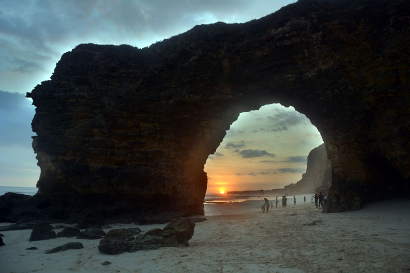
The southern road goes over a bridge. After 500 meters, a road branches off to Watu Parunu Beach. The beach has very fine sand; the waves come in shallow and comfortably. When you continue you will reach Pintu Parunu, a picturesque gate in the rock. To get there you have to take one of the dirt tracks towards the coast before the road goes uphill. Altogether you can make a nice circular walk of 2 hours from this. Please do not bathe near the river mouth – definitely crocodiles live here. The rock arch is visually – but not geographically – the south end of Sumba. Behind Pintu Parunu the street is an adventure.
The South of Sumba
From the South tip of Sumba to Wanokaka in the Southwest
Along the south coast, between Baing in the east and Wanokaka in the West, there are only occasional road links – in some cases there are only access roads from the north to the south coast. Bridges are rare, so that you cannot get through in monsoon season. People live only where the land is fertile, and you only find trucks there. Otherwise, you have to rely on your own vehicle. The first few kilometres behind Pintu Parunu show you what to expect further on.
Although the road to the west of Baing was paved some time, but is eroded totally, and nearly no longer passable. 7 times you have to wade through a small river and kilometres long over rubble. The first part of track was uninhabited until recently, but now people live here for seaweed cultures. Here you cross the nature reserve of Tanjung Ngunju. The landscape is tropical green – countless butterflies and birds flutter around you while monkeys hide in the thicket. You drive past beautiful bays and beaches, over several mountain ranges and rivers, until you see human beings again in Kakaha. The beach of Kakaha, Manoekangga is about 10 km long, untouched, white and has fine sand. It is nice to look at, but swimming is only possible at low tide because of strong undercurrent. In this area there are no traditional villages but many new settlements. People live on fertile plains and do farming.
You also get directly to Kakaha via the mountain road from Waingapu or Melolo. You also have to use this road if you want to go further west. After crossing the Nggongi River, you have to turn south to Nggongi (Ngonggi). There is a lot of farming in this area. More people live here, they are farmers and it is beautifully green. Nggongi itself lies in the flood plain and has many large wooden traditional houses and very impressive tombs. Most are brightly painted. Just off the coast is the village of Lalindi. From Lalindi a small stone path leads to the river mouth and to Waihungu (Tabuati) beach. The beach is constantly shaped by the river mouth and is only suitable for swimming when the surf is moderate.
From Lalindi you have a great view of the highest mountain of Sumba Palindi Wanggameti. To the mountaintop you can only get from the inland. A detailed description can be found via the link site. Starting point for this hike is Desa Wanggameti.
Continuing to Tawui you dip into the jungle on the southern edge of Laiwangi Wanggameti National Park. It goes inland, past many rivers and tropical vegetation. The road is completely eroded with many dangerous steep descents.
There is only one single and new paved turn-off on the route towards the coast. 2 km downstream you reach Katundu. Katundu is a tiny sleepy village. It has a nice bright coral beach which is well protected by a reef. At low tide you can walk around the steep rocky walls to neighbouring bays. Once a week, there seems to be a boat to the southern offshore island of Salura. 26 Families or 660 Muslim People live there. Visitors of other religions are possibly not welcome. Soon a pier for boats to Salura will be built. The neighbouring Manggudu Island is uninhabited. There was a surfing resort. It was vacated by the Indonesian army because of contentions between Mr. David and the Indonesian administration.
Back to the main line the road leads over a stone beach to Lailunggi. Here end the trucks coming from Waingapu via the road to Tarimbang, Wahang and Tawui or the other way around over Kananggar Nggongi. Lailunggi is located in the plain of the Bokul and Watumbelar River. All around are agricultural areas. The beach of Lailunggi is mostly rocky. But at low tide you will find some sandy areas and with moderate surf you can swim quite safely.
The shortest route from Waingapu to Lailunggi is via Tanarara, Desa Wanggameti, Katikuwai, Ramuk, and past the mountain village of Mahaniwa. The road is good only in the area of the gold mining project. Trucks go as far as Ramuk. From Ramuk to Lailunggi it is more a mountain trail than a road – maybe passable by Motorbike. In the plain the way ends like a river bed. In the rainy season this part of the way is difficult to make – even for hikers. On the way 3 rivers and many creeks have to be crossed. Sometimes crossing is not possible without help. Nevertheless, the route through the mountains of the Laiwangi Wanggameti National Park is uniquely beautiful. Traditional villages are stuck picturesquely on the slopes and you have a magnificent view of the mountains overgrown with green jungle. One option would therefore be to drive up to Ramuk by truck and hike the remaining 13 km with a descent of 700 meters. Another option would be to hike from Ramuk via Mahaniwa, and Waikanabu to the region of Karita at the road Tarimbang – Wahang. This is about a 22 Km unexplored way, therefore you need a guide. The waterfall Waikanabu is situated in that area.
6 km west of Lailunggi you reach the village and most beautiful beach of Sumba, Tawui. The beach is almost 8 km long and sometimes up to 200 meters wide. It consists of almost white fine sandy material. There is strong but steady surf (parallel to the beach and too short for surfing). In some places, especially at the 2 ends of the beach, there are rocks in the water, which may be covered at high tide. Apart from water buffaloes and Sumba horses no one bathes in Tawui. The beach is reached via narrow trails leading through fields of fragrant spice bushes. Several small settlements and the district administration lie behind the beach.
If you walk over the cliffs to the east, you have a breathtaking panorama, and ultimately come to a bay for fishing boats. If you walk inland, you pass many farms and fields. Some small traditional settlements are in this area. One of these ways begins to the right of the primary school. It leads into a 2015 newly created dangerously narrow and steep motorcycle path. There, in the mountains you will have a great all-round visibility. 2 km before the small waterfall Cengkeh the Motorcycle path ends and you have to descend on foot the rest. From Lailunggi, via Wanggabewa and Laitaku with motorbike and 8 Km by foot you can get to the impressive Kahalatau waterfall. It is worth seeing mainly in the rainy season but difficult to reach since it is hidden in the jungle. Both destinations can be combined. Perhaps you find someone from the local National Park Administration “Tawuiresort”, who can show you the way.
The road to the west has extremely eroded slopes. The village of Wahang is at the next bay and has only a small beach. Wahang winds far inland along the river. With increasing altitude, the landscape becomes more tropical. After about 5 km the houses end and the road leads through primary tropical forest. Here it dips again into Laiwangi Wanggameti National Park. Some kilometres behind the pass a small path branches off eastwards to the upper end of the waterfall Laputi (Laiputi). Here is an orphaned picnic area, a small jungle lake, and you have a beautiful view over the valley. A little further, at the beginning of the village, turn eastwards to the foot of the waterfall, this is about 1 km away. Even in the monsoon season, there isn’t a lot of water but its height of 100 meters and the lush greenery around are quite impressive. Back on the main road, it is 500 meters to the traditional village of Praingkareha.
About 3 km from Praingkareha before a curve an access road forks to the southwest. It is partly new asphalted and ends abrupt at a river crossing. Just a few hundred meters before, a jungle trail leads after 500 meter northwest to the Laindamuki (Laluku) waterfall. The crocodiles are not supposed to be aggressive. The road then goes further down to the village of Pindu Hurani and the coast, but is not really passable. Above the coast you can reach some traditional villages by foot. The beach is not really suitable for bathing because of the strong undercurrent. Alternatively, you can reach this area in a day hike from Tarimbang.
From Praingkareha the road goes inland along the river. You see many new settlement areas, relatively large and prosperous villages and fields everywhere.
In the village Karita shortly before the river bridge a road branches off to the east. It meanders through gorgeous green river valleys and over green hills past the traditional village Watubakul to Waikanabu. Then it ends in small paths. Another branch leads, where the main road turns to the west, along the north bank of the river until Kukitalu. At the end of both side roads are paths continuing northeast across the island. After about 13 Km these paths end at Kambaniru River. From the east bank there is a road that leads to the side road Waingapu Tanarara.
The main road however winds around this uninhabited center of the island for kilometres along Alang grass covered hills, until it meets at last the Praipaha-Tarimbang road at Simpang Tabundung.
In Tarimbang you will see tourists again. The village lies at the mouth of a river delta. In the plain you don’t need a guide. In the dry season, distances are short – in the monsoon season you must walk around the fields and meanders of the river. Upstream are several Marapu villages and a dam. Through this, irrigation of the delta will once be regulated. Further on this path are a small waterfall and finally the way goes uphill and leads back to the main road. You can only reach the adjoining bays with a guide, as the jungle is too confusing. To the east you reach Pindu Hurani and other beautiful original and traditional villages (cf. above) within a few hours. To the west Mambang bay can be reached in a few hours. It is one of the most beautiful bays and beaches of Sumba. Mambang bay is also accessible by foot via a completely overgrown driveway from Praibakul to Kambaru (cf. below).
Tarimbang can be reached directly from Waingapu or Waikabubak, when you leave the connecting road between the 2 towns at the village of Praipaha (km 47) and then turn to the south opposite the telephone mast. You must also return there if you want to go to one of the 2 main towns. Some trucks do not drive up to Tarimbang but turn 10 km before, at Simpang Tabundung, in direction of Lailunggi.
West of the Praipaha Tarimbang road there are some new settlement areas. On the Tarimbang road, in Lailara, a recently constructed gravel road branches there. This road leads also to the traditional village of Praibakul. The gravel road ends behind a new settlement area. Then there is only a marked-out path which leads to the beautiful, white sandy beach of Kambaru (Kambaroe, Kakadu, Kakadoe, Lakakadung), and a trail to Mambang. Both beaches and the jungle around it are uninhabited. The hike to Kambaru is about 10 Km with a 400 meters descent and easy to find – and further via Mambang to Tarimbang it would be in total 25 Km and difficult to find.
Praipaha on the road Waingapu- Waikabubak is the last major town in the northern direction. Roads further to the north end when settlements end – depending on the season in a beautifully green or brown hilly landscape.
We continue westward. The milestones on the roadside are important for birdwatchers: Shortly after Lewa Km 7 or Waingapu Km 50, a path branches off towards the south. At another junction you must keep to the left. Then you dive into a jungle valley with many clearings. This is the place where birdwatchers claim that you can see all the endemic birds of Sumba. At Lewa km 5 or Waingapu Km 52 a road branches off to the north and leads to some natural lakes like Lairini and several others, nestling between rounded limestone hills. Along the densely covered banks many birds can be seen. For non-birdwatchers both locations are worth visiting because of their scenic beauty. The best time for bird watching is (too) early in the morning and at late dusk.
Back to the road Waingapu- Waikabubak, the next town west is Lewa. Lewa is only a transit point and offers hardly any tourist attractions. The Lewa plain is a great agricultural area. A long time ago, the first villages of transmigration programs were created here. If you turn south at the sign Tanarara at the eastern entrance of town, or at the sign Kangeli 1 km west of the gas station, you come to the southern plateau. There are also some traditional settlements on the way. The road then finally drops down to the coast to the village of Mondulambi (Omatena). Rice is grown around the irrigated Tidas River delta. The amount of water is enough for 2 harvests per year. Everything is beautifully green. From the village to Mondu (Tidas, Kiriwei) beach it is another 5 km along the river delta and mangrove forest. Monkeys, birds, and butterflies will accompany you. The beach is characterized by a shallow estuary. Depending on the tide the water reaches up to the mangroves or is up to 300 meters wide with white and fine sand. When there are not any high waves you can swim everywhere; otherwise you have to be careful.
Lewa is located on the eastern edge of Manupeu Tanah Daru National Park. Here is another paradise for birdwatchers and it is also worth visiting for nature lovers. You must pay an admission fee for the national park and you need a guide who accompanies you. The National Park Office Kantor Wilayah SPTN is north of the market building. Here you can also get a detailed brochure about flora, fauna, waterfalls, beaches, and caves in the park. Destinations within the park include Watumbelar, about 20 km south of Lewa. Here you can hike deep into the jungle. The knowledgeable guides show you the birds you can hear, on the display of their mobile phones. Or they play the bird calls in order to attract birds. On the way to Langgaliru, 6 km west you can already see birds from the road and visit an abandoned village and a Marapu sacrificial place in the jungle. A gruelling 2-day tour takes you across the park to the south coast to the beaches of Laitucu and Otur. One of the highlights of this park is the easily accessible meteor impact, Dampak Meteor (Jatuh Meteor). The meteor has stamped a crater 150 meters in diameter into the earth and exposed an underground river in the limestone. This river emerges from a cave on one crater wall and disappears into the floor at the other side of the crater. In the dry season you can descend into the 80meter deep crater. The trail to the crater begins at LGR km 8 – through Alang grass.
9 km north of Lewa at Rakawatu is the lake Danau Rini. After monsoon season, it measures up to 75 hectares. During this time, hundreds of Australian pelicans nest here. By the end of the dry season the water level falls up to 6 meters and the lake shrink to a small pond.
Shortly after crossing the eastern part of Manupeu Tanah Daru National Park at Langgaliru the administrative district of East Sumba ends.
Waibakul, Anakalang and Surroundings
The only road from Lewa further west runs inland. The landscape is more and more gentle and increasingly green. Sometimes it goes through mountain areas, partly along river valleys. Finally, you will pass through the western part of Manupeu Tanah Daru National Park. Here are predominantly high dense deciduous forests. After about 35 km you reach the 400 meter high plain of the Anakalang district and the capital of the new district of Sumba Tengah, Waibakul. Actually it is not a real town – but they have already planted a few dozen ugly new administration buildings in the middle of rice fields.
In this district you find the largest megalithic tombs of Sumba. Starting point to visit this area is the impressive traditional village Pasunga, right across the junction to the south and the market. Who is in transit from Waingapu to Waikabubak, can leave the luggage in any of Warung. The village of Pasunga has several huge megalithic tombs. The villagers are very accustomed to tourists.
If you follow the broad street to the south you reach the traditional village of Kabunduk after 1 km on the right side. In this village new and old is mixed. Here lives the chairman of Kabupaten Sumba Tengah. His home can easily be recognized by the carport in front of the traditional dwelling. From this village you can get – probably not without accompaniment – to the nearby historical Kampung Makatakeri and Lai Tarung. From these villages you have a spectacular view at the plain covered with rice fields.
Further south, along the rice fields, you come to Gallubakul after 2.5 km just off the road you’ll find the biggest megalithic grave in Sumba (70 tons). Behind and diagonally opposite are 3 large traditional villages. If you want to see traditional houses with alang- instead corrugated iron roofs in the Anakalang area, you must go a few kilometres away from the main roads.
From this location a road leads to the south coast again. After about 30 km to the southeast, in the middle of Manupeu Tanah Daru National Park, you reach the bays and beaches Konda, Maloba, and Aili. In older guidebooks this is named usually “Kondamaloba” – the new tourist name shall be “Tanahmas”. The way to get there is through agricultural areas, coffee plantations and then through hilly terrain overgrown with Alang grass. From the park entrance with a height of 650 meters begins the descent into these bays. Finally, the road splits. The road to the eastern bay Konda is dangerous steep and unpaved. The bay is almost uninhabited. The beach is black and mostly sandy and shallow. The surf is steady but not dangerous. The beach is 5 km long with some impressive rock barriers in between. The road to the western bays Maloba and Aili is paved. The bays are tropical green and with a lot of flowers. The Sendi Praigaya River plain is overgrown with jungle. Many monkeys, birds, and butterflies live in it. Inland there is a small village. There are 3 beaches; they have all fine bright
yellow sand. The 2 side beaches have no waves; the main beach has pleasantly cooling surf.
You can also reach these bays with a hired boat for instance from one of the fishermen in Waihura in Wanokaka. There are no other direct connections between Konda, Maloba, and Wanokaka.
From Gallubakul there is also a 9 km southwest road to Mata Yangu Waterfall. From Waikabubak to the waterfall it is 15 km towards Waibakul, then turn straight forward south 10 km at the sign “Dameka”.
There is no entrance gate to the national park but some confusing direction signs. From there continue the road about 3 Km more south. Somewhere at the way, on the left side there is another sign. From there, you have to ask around. It goes cross country through Alang grass and jungle – 200 meters downhill – remember you’ll have to climb up on your way back! The waterfall tumbles 100 meters down into a turquoise pool. Perfect after a long hike. Everything is beautifully green and many birds and butterflies buzz around you. From Mata Yangu to Lai Popu waterfall downstream it is 1.5 km jungle and another 100 meters downhill. The 2 tracks are almost invisible, it is slippery in the jungle, and often the way is blocked by fallen rocks and tree trunks. Without a guide, good condition, sturdy shoes, and plenty of water these tours are not feasible.
When you turn left at the park entrance signs, you come via an eroded side road to Hupumada (Hupamada) on the east side of the river delta of Wanokaka. 3 km on that road you come to a piece of jungle, which is frequently visited by birdwatchers. 2 Km further there is a school.
The first way to the south is mostly unpaved and dangerous steep. It goes down to the south coast and the traditional village and beach Tangairi. If you turn west before, the first possible path, you come to Lailiang beach and ultimately also to the east side of the river delta of Wanokaka.
The second way to the south leads to the widely extended traditional village Lahona. It is deeply embedded in the jungle around it are many rice terraces.
For the western part of Manupeu Tanah Daru National Park you can get a guide in the Waikabubak National Park office in Jalan Adhyaksa Km 3.
Waikabubak and Surroundings
20 km west of Waibakul is Waikabubak, situated 400 meters on a plateau and with a pleasant climate. The town is a good starting point for exploring nearby traditional villages and attractions in Central and West Sumba.
The centre is tiny and has only a few longitudinal and cross streets. In the evening water buffaloes and horses are driven through the town and at the central crossing soccer is played. The 2 and solar-powered traffic lights stop working soon after sunset.
The town also has a tourist office. The employees are well informed about what’s happening in town and its immediate surroundings. It is at the extension of Jalan Veteran in the vicinity of hotel Artha.
Nearly on every wooded hill in town and around there are traditional villages. To explore them you need no guide.
Direct in town are:
– Kampung Tambelar lies within sight of the soccer field
– Kampung Bodo Ede, Tarung and Waitabar west of Jalan Ahmad Yani
– One village is located east of Jalan Ahmad Yani via by a small driveway
– One village north of Jalan Veteran, in sight of Artha Hotel
– Four villages are located southwest of the bus station, between rice fields
Seventeen villages are located east of Jalan Gajah Mada and south of the street to Waingapu. These include Kampung Elu, Praiijing, Gollu, Bondomarotto, Prairami, and Primkateti. All are within walking distance; the farthest is 4 km away from town.
A little further away, up to 12 Km north of the town and less often visited, are many other villages, including Kampung Ratuwanu, Tambera and Gelukoko.
A hike to traditional villages east of Waikabubak can be combined with a subsequent descent to the river delta of Wanokaka. For that you start east of Jalan Gajah Mada then hike from village to village eastwards. After about 3 km (as the crow flies) you come to a small road which is slowly curving down to the south and ends after 10 km at the Wanokaka Waikabubak road. On the way back you take a Bemo. Alternatively, a circular route with views of Wanokaka and back to Waikabubak is possible. Alternatively you can go down to Lai Popu waterfall (cf. below) and try to get a hike back.
Another hike leads towards Lamboya. It begins in Weekarou, south of Waikabubak along the government buildings. From there, it just goes straight on, initially along the edge of the plateau and then all the time downhill. On the way you have great views of the rice terraces on the hillside. Some traditional villages are on the way and at the end you come to the traditional village Sodan (Sodana). Then you need to climb up 100 meters to Kabukarudi. There you take a Bemo back. Overall this is 17 Km.
West of Waikabubak offers 2 tours: Go by Bemo 10 km up to the sign Waikelo Sawah. There is a small waterfall in southern direction and later down the road there is a great view of irrigated rice fields on the plateau.
Or go by Bemo 13 km up to the sign Loko Winne. South of the road you reach interesting grave fields. On the hills around the graves are several traditional villages. Particularly noteworthy is the original Marapu village of Weelewo.
You have to walk there and back, but you can combine the 2 destinations by walking south of the main road from one destination to the other. It is difficult to get lost here, the area is densely populated.
The Southwest of Sumba
Wanokaka to the western tip of Sumba
Just a few kilometres south of Waikabubak you have a magnificent view of the vast Wanokaka River delta of Wanokaka (Wanukaka) district, with rice fields and the southwest coastal area of Lamboya district. Rising hot air out of the plain forms a strong thermal wind, bald eagle and other large birds glide up in circles. You are almost at the beach. But in between, there’s much to look at.
After 8 km the road to Lamboya branches off to the west. Continue downhill to Wanokaka. After 4 km on valley bottom you come to Taramanu. It begins on the east of the road and winds around the river and rice fields in the plain. Taramanu has many traditional houses.
You also get to Taramanu when you turn 3 km east of Waikabubak into the side road to the south (at the corner are about 7 tombs). This road leads to the end of Taramanu before the second river bridge. The last monsoon has taken away a lot of this road.
The waterfall Lai Popu can be reached when you turn left 500 meters behind the second river bridge. You will not manage to walk there on your own because villagers are waiting to escort you at the end of the road. The path leads along the river, across rice fields, 2 bamboo bridges and through beautiful, green jungle. Expect about an hour’s walk. The path is not difficult but wet and slippery. The waterfall drops down sixty meters over many cascades. You can swim in the river. The road from Taramanu to Lai Popu has just been completed in 2013 and it unfortunately destroys all tropical magic – too bad since the journey was the reward.
Turning back and then left you come to the eastern edge of the river delta. Here are many traditional villages, for instance the village of Hupumada (Humupada) at the first turnoff. The village itself is now mainly in the plain, but the traditional part and the Rumah Adat are still on the mountain top. A dangerously steep gravel road has just been built up there. From the top you have a great view of the river delta.
If you follow the way at Hupumada eastwards, you come via Lahona ultimately to Waibakul and Anakalang (cf. above).
Finally the main road ends and you climb steadily uphill. A few kilometres further you come to a settlement built in 2008. For this settlement they built a gravel road to a small private mini beach. Another road leads to the idyllic Lailiang beach with white sand, clear water, and little surf. At the end of this beach, the road continues further into the tropical Waikadjelu River valley and paths lead to other jungle villages.
Back on main road, 16 km from Waikabubak, on top of a hill, is the traditional village of Waigalli and just beneath Praigoli. Both villages have impressive megalithic tombs, the oldest are in Praigoli and these are the oldest in Sumba. In Praigoli you find also the most famous megalithic stone of Sumba the fleur-de-lis or “Lakaruka Jiwa Tada Bita Laka”. From both places and their surroundings you have great views over the bay. Unfortunately, not all houses are roofed with Alang grass, and you can tell from people’s behaviour that quite a few tourists pass here.
Past the bleachers of the Hoba Kalla Pasola, after 18 km, you arrive at Wanokaka beach and the tiny dreamy fishing village of Waihura. It is crowded here when there is a lot of fish, around monsoon and at the March Pasola. The flat white beach borders on the 4 Km wide river delta. If the water is not too high you can walk through the river to the other side of the river delta and look for a place with reasonable surf. The beach is accessible only from the west side. Far out I once saw some kite-surfers …
From Wanokaka to the west you walk over hilly terrain and past numerous traditional villages to the village and Rua beach. You start at the traditional village Wangli near the last bend before the lagoon or at the fishing village Waihura on the beach of Wanokaka. With every meter height the view on the bay is more beautiful. Then you reach the village of Waiwuang – with surely the best views of the bay. There are quite a few paths from village to village. You need to ask locals for the way. From the beautiful village of Pahola you can descend to the beach of Rua. Expect at least 4 hours, with 300 meters ascend and descend. If you need a road, you must return to Praigoli, there is a road to Rua. The road to Waiwuang turns off half way at a primary school.
The view of the bay of Rua is ruined by a dilapidated pier and a run-down water park resort. The beach to the east of the pier is 2 km long and consists of fine white sand. You will find a calm place for bathing somewhere even when the surf is strong. On the beach to the west of the pier is a lot of seaweed and garbage because of fishing.
In the next bay to the west is the Nihiwatu resort. As an Indonesian or a simple traveller you are not welcome there. All roads are blocked there because the owners want it that way. Directly above or behind Nihiwatu are many traditional villages, they can be reached by usually unpaved roads. The main roads run inland, around the resort. Half way you reach the village of Kabukarudi.
From there you can see the pointed roofs of Sodan (Sodana) beyond the river valley on the hilltop. Sodan is the village with the highest ascend in Sumba. To get there you need to cross the Kadengar River. You start opposite the market of Kabukarudi. On the opposite side of the river, a new path is under construction. It leads with several switchbacks to the village. Or you can go up straight the original direct way, in total 180 vertical meters. Another possibility for getting up begins 2.2 km further west from of main road in a curve. First go down to the river, then along it, then past several picturesque traditional villages, straight up. Both ways are worthwhile, it is really quite original and super scenic.
The traditional village of Kadengar (Kadengara), a few kilometres further west was completely destroyed by fire in 2009 and is now resurrected in corrugated iron at the bottom of the former hill of the village – what a pity. But in the valley of the Kadengar River there are other villages that have retained their original character.
On the hill behind the bridge over the river, you come to a fork of the road and a grandstand. Here the February Pasola is held. Throughout the year, local people are training here. Straight on the road leads after 3.5 km to Marosi (Tarikaha) beach. Before, after 1.5 km on the right you see the Sumba Nautil resort with the chalet of the owner. Left of the road several ways lead to very picturesque traditional villages like Waru Wora and the beaches Etreat and Kerewe (Kerewee, Kerewei). In Marosi a site for a proposed hotel is already fenced, tourism begins…
You can turn right along the beach or left over cliffs to the neighbouring beaches and look for a suitable swimming, surfing or kite-surfing area. Marosi, however, has the clearest water and the lightest sand. The beach is protected by a reef which has established itself on a sunken volcano on the right hand side.
Directly at the junction to Marosi or 1.5 km further west or 2.5 km further at the traditional village of Litikaha roads go inland up to Tokahale and Malisu (Nalisu). From there you have a super view over the beach and the reef. There is also kept an anchor from a British ship that ran aground in 1838. The residents do not seem quite so happy about many tourists visiting them.
Shortly behind this place, the area for tourist’s ends, people become friendlier again. From the main line many tracks and paths branch off towards the coast. They usually lead to small traditional villages above the predominantly steep coast, but also to some small beaches, such as Gaura. So you have to ask your way. There are also a few potential surf spots for experts. Things change in this area. In Ngedo an “Eco farm stay/yoga retreat” is planned and in Watukaka an “All inclusive resort” is under construction.
Shortly behind Weetana the road becomes very poor. To Kodi there is no direct transportation. Locals prefer the detour via Waikabubak and Waitabula.
But the direct route is worthwhile. The landscape varies from savannah to tropical forest and grazing areas to cocoa plantation, from plains to mountains. The people live in scattered farms or in small traditional villages.
At the exit of Weetana an initially good road leads to the place of the March Pasola Weetana / Gaura. There is a great view of the rocky coast and surf to the east. To the west Mambang beach begins (there are 2 with this name on Sumba). The panorama ends at cape Tanjung Mambang. Here there are only climbing paths down to the beach. The eastern and smaller section of the beach is bordered by a river. But you can wade through (further cf. below).
3 km after leaving the village of Weetana a road branches off inland. It is the only drivable connection from here to the north. It goes first through hilly country, through new planted Cassava plantations up to the Polapare River. The main road goes along between the river and wooded ridges, and it ends at Elopada, west of Waikabubak. Along the route are lots of birds and monkeys. Halfway you come to Dikira. From there a climb to the holy mountain Palindi Jawila (Yawila) is possible (ask the Kepala Desa), and you can visit the small Lokomboro Waterfall near the PLN power station.
The side road branches off northwest, right behind the bridge over the Polapare River. About an initially rocky track this leads via Waikara to the main road Waimagura Waitabula. In Delo (Dello) is a way west to the Waterfall Pabeti Lakera. There are 2 paths that lead to the fall, one to the upper part and one to the bottom. 500 meter thereafter is a road eastwards that leads to the beautiful located traditional village Umbu Koba. Shortly thereafter, at Tena Teke a road branches west. South of this road are the 2 nice traditional villages, Manola and Mandeka.
Back to the Kodi Road: 2 km further the bad road to Kodi turns west. The good road leads straight to the western part of the Mambang bay. There is a small village. The people plant rice in the plain and are fishing. Some visitors to the Pasola use this place to stay and then wade along the beach to the Pasola place. The western part of Mambang beach is 3 km long and marvellous. Some small rock barriers can easily be managed. The beach is protected by a reef – so far away that there is pleasant surf again. The construction of a hotel will soon begin …
Directly behind Tanjung Mambang is another beach. You have to explore the way there yourself, but the landscape is relatively open. This beach is not protected by a reef and has generally strong surf.
Halfway between the road to Kodi and Mambang a gravel road branches off to the east. It leads to the surfer beach Katobo (Katoba) with extremely strong surf.
Continuing towards Kodi you drive for miles through a cocoa plantation. From the workers’ settlement of the cocoa plantation, a farm track and path leads to a narrow but very quiet beach Rita.
At the end of the cocoa plantation you have to cross the Polapare River. The descent to the bridge is dangerous; some vehicles have already landed in the river. The rocks and beaches at the river mouth are called Watu Malando (Watu Maladong). From the bridge, you cannot get there. You must ride 3 km from the bridge to the school Panenggo. There turn left and take the second path to the left again. Because of the tides and currents Watu Malando is not suitable for swimming but just something to look at: white limestone cliffs, blue water, and lush tropical foliage, gorgeous.
About 3 km further there are several paths that lead towards the cliffs and also to various beaches. Just ask the locals for the way. Here the water is crystal clear, but the surf is often too strong for swimming.
Just before the steep descent to the bridge over the Mocha (Mokka, Lambatana) River, turn west for Wainyapu. Wainyapu is another place for the March Pasola. For this a huge field with stands has been built. The village itself looks more like a museum than something where people really live. There are 30-40 traditional houses – but the amount does not really count.
8 km further you reach Bondokodi in the district of Kodi. Kodi is the westernmost district of Sumba. It is well known for the highest roofs of traditional houses. Sometimes these roofs look like pointed caps, they bend somewhat – lacking only the bobble. Tourists also come because of the beaches and for surfing. You can bathe for sure, but if you are looking for gorgeous tropical beaches, you will be disappointed.
Despite the protective reef the surf is very strong at high tide. Beaches stretch about 20 km from the western tip of Sumba to the southeast. Bondokodi is the regional centre and 2 km from the coast, Pero (Perro), a small village at the coast. Bondokodi is Christian – Pero Muslim. Both places are the starting point for excursions to villages in the area.
To the southeast, the following round trail of about 10 km is possible: In Pero you must be ferried across the Bondokodi River. Then walk along the beach to the megalithic grave stone on Ratenggaro beach. The village on the other side of the river and the bay is Wainyapu. To get there you must cross the river – by boat or on foot at low tide (cf. Wainyapu above). Then back again across the river and along the road. First you will pass the village of Ratenggaro. At the entrance of the village you see delicately decorated tombs. Several of the village houses have been rebuilt after a major fire with the help of a wealthy Indonesian woman. 500 meters further you will pass the village of Paranobaroro. There is the house of the Rajah of Kodi with the supposedly highest roof in Sumba. On the way back you pass other villages. Via the river bridge, you get back to Bondokodi and Pero.
In north western direction, from Pero over narrow paths behind the beach or from Bondokodi over the asphalt road, you reach the first villages and burial grounds after about 2.5 km. In about 6 km you come to Tosi (Tossi). There are also stands for the February Pasola. Along the road one village follows another and one burial ground another.
The western tip of Sumba is again extremely dry. A narrow road splits from the traditional village Waikaroko and runs parallel to the coast through the savannah to the traditional village and beach Karoso (Karosso). Here the beach is wider again, with fine sand and pleasant surf. Further east, steep cliffs begin. Between the rocks is the beach Mandorak, a small landing for boats and the turquoise lagoon Danau Wee Kuri, which has an underground connection with the sea. Here ends the for tourist laid way along the coast.
Further east up to short before Waikelo are some very tiny beaches. They are so small that fishing boats have to be pulled up by ropes during high tide. To this area you get through a maze of newly created gravel or tourist roads. Between Pemuda and Waitabula several ways leads to 2 circular sinkholes filled with brackish water (this are no salt lakes). All around, it’s lovely green.
The coastal strip between Kodi and Waitabula is densely populated with intensive agriculture. People live scattered in their lands or in traditional villages. The harvest is often not enough to live on, because of the drought. This area is one of the poorest in Sumba.
Traditional villages are not only near the coast but also inland. Further away from the coast, it gets wetter and the ground more fertile. Small villages are everywhere, hidden in dense foliage. On the way towards Waitabula you also pass teak, banana, and cashew nut plantations.
Alternative to the main road Kodi-Waitabula, there is also a possibility to drive from the south of Bondokodi via a mountainous area and villages Matakaporo and Marokota, to Waitabula or Waikabubak. The scenery there is beautiful and green, it is lonelier but the road is partially eroded. The southern direct road to Waikabubak is difficult to pass between Waikara and Dikira.
Waitabula, Tambolaka + Surroundings
The area between Waikabubak and Waitabula is densely populated. There are more modern buildings; traditional settlements are located further away from the road. All the year round the area is green and is used intensively for agriculture. Before you go down to the dry north-western plain you have a fantastic view of the region.
There is Waitabula (Weetebula), the “capital” of the newly formed district Kabupaten Sumba Barat Daya and next to it Tambolaka. Sometimes the town is called Tambolaka, like the airport. In town is the centre of the Catholic Church of Sumba. Waitabula has a cathedral, the hospital Rumah Sakit Karitas, a Rumah Kolping and a kind of monastery, Rumah Retreat St. Alfonsus. This is a well maintained property with monks’ cells, cloisters and meeting rooms. It is a place of peace and seems to belong to a different world. Waitabula is also a trading centre for west-facing villages. It has the largest and permanent market on Sumba and a 2 lane main road. As a precaution the ugly and swanky new office buildings were built westwards, 10 km towards Pero in Kadula. 2 km towards Pero is the Sumba Cultural Research Conservation Institute. It was founded and is directed by Father Robert Ramone (cf. Links for his website). It has an extensive collection which is well worth seeing. Also the buildings themselves and the surrounding Palm Garden are very special.
The Tambolaka airport is situated north of Waitabula and the coastal and harbour town of Waikelo. Waikelo has the only port for large vessels in West Sumba. From here a ferry goes to Sumbawa. West of the harbour is a beautiful white sandy beach. The inhabitants of Waikelo are Muslims originating from Bugis. The magnificently painted houses are in total contrast to the rather sandy brown surroundings. It’s very quiet here – unless a ship is coming in.
12 km further east is another Muslim settlement of Bugis, Katewel (Katewela), quiet and even dreamier, with a mosque from 1001. The village has a beautiful sandy beach. The beach to the east is Kawona. It will soon be exploited commercially… and in the inland Jatropha plantations are planned. The residents of both towns are fishermen. They also boil salt with washed up tree trunks for fire wood. The coastal region is very dry and agricultural use is not possible.
Between the 2 places, the new tourist spot Mananga Amba (Kita) is planned. A hotel and a road along the coast just have been built. The hinterland, however, is completely dry and uninteresting. Vegetation and trees are only at the western edge of this area. There is the small traditional village Oro. After several fires it has only been partly rebuilt in the original way. Next to it is a small same-named resort with a beach.
Only a few kilometres inland it is green and there are cashew nut plantations. Partly, the water from mountainous areas is led here and used to irrigate the plains for rice cultivation. At the foot of the first mountains there are traditional Sumba villages again.
To 2 of these villages, Bondo and Kapambu, you get like this: before the road turns to Katewel at Karuni there is a burial ground, there you take one of the 2 paths and go upwards. Both villages are predominantly Marapu villages and still well preserved in their structure. There is a great view from one village to the other and to the coastal plain.
The village Totok (Chotok, Chodok) is more difficult to reach: Just off the bend to Katewel you have to drive inland along the paved road. Always keep right. The village can be seen from afar at the right. The road goes up to 400 meters and after 8 km you reach the village. The last steep kilometres consist of concrete lanes. Due to the location and views, as well as its originality Totok is one of the most beautiful villages of Sumba.
The Northwest of Sumba
From Waitabula to the northern tip of Sumba
This area is similar to the northeast of Sumba and extremely dry. Just after the monsoon, the landscape is lime green. Otherwise, only valleys and estuaries of rivers are lush green like oases in a terra cotta coloured hilly area. Unfortunately, in the dry season people partially burn the vegetation so that the hills sometimes look black. In the river valleys bananas and rice are grown, and corn in the semi-arid areas . The landscape hardly changes along the north-western coast. Only on the hills many kilometres inland it becomes lush green, and agricultural land begins again.
Between Lokory in the west and Mamboro, the only major town in the area, there are few villages. 1 km behind the junction of the road from Waikabubak you get to the beautiful traditional village, Waiwarongu; there you must turn towards the coast. All the houses are still covered with Alang grass and there are many interesting tombs. Right of the village is a small path that leads to the beach and the river estuary. You should not bathe near the estuary because there might be crocodiles. 7 km further is Mamboro (Memboro). This place is divided into a Muslim district of immigrants and various traditional Christian or Marapu villages. The Muslims are mainly fishermen and live right on the beautiful sandy beach and the Kalada River mouth. The villages around are situated in the flood plain and on the mountains. From the traditional village Manua Kalada you have a magnificent view of the deep green river plain and surrounding mountains.
Between Mamboro and Kadahang there are only a few river valleys and estuaries, and only there a few original settlements. Along the road and the beaches a lot of new settlement projects were produced from thin air – however, many houses and some entire villages have since been abandoned.
There are sandy sections in many places on the coast. Beaches are not special but truly natural. There is only little vegetation, no shade, and no infrastructure. Exceptions are Mamboro Bay and Lenang, half way between Mamboro and Kadahang.
The roads are mostly asphalted. If you’re travelling by motorcycle you maybe reach Waingapu faster from Tambolaka than by the inland road – even despite terrible sections – hopefully you have no breakdown. The road from Waibakul to Mamboro is throughout in good shape. The road from Waikabubak to Mamboro varies from super to shitty. The road from Waikabubak to Lokory goes from Ekapata in a western bow through a very scenic area and is partially brand new. The remaining roads are mostly simple and go from village to village. Through trucks are rare on these roads.
At the end of Lenang bay shortly before the northern tip, the road turns inland and then goes eastward. You will see the traditional village of Wunga, the starting point of this description, 7 km off the east coast.
Source: http://www.sumba-information.com/where-to-go9.html#%20oben


-

- SONY DSC


-

- Adat village of Rende, Sumba, East Nusa Tenggara, Indonesia


-

- Traditional adat village in Sumba, East Nusa Tenggara, Indonesia


5 Dec
0
Sumba Island Adventure Tours 3 Days 2 Nights
– Start/Finish : Tambolaka Airport
– Grade : Easy
– Minimum Pax : 02 Person
– Hotel/Resort : Sinar Tambolaka Hotel or Similar
Itinerary:
Days 01 : Bali – Tambolaka (Waikabubak – West Sumba)
Pick up service at your hotel and in Bali, transfer to the airport for your morning flight leaving for Tambolaka in the western part of Sumba island.Upon arrival at Tambolaka airport, meeting service and direct transfer to Manandang Hotel or Monalisa Hotel. Lunch and dinner provided. Afternoon Puu Naga, Tambeler and Tarung the most bautiful traditional Sumba village with their unique architecture. Overnight at Hotel.
Day 02 : Waikabubak – Sumba Village Tours
After breakfast, drive to Kodi district with enroute stop at Tambolaka and Waimangura village. Arrive at Kodi visit Ratenegaro and Pronobaroro village that have the highest roofs and biggest tombs on the island. Return to Waikabubak. All meals provided. Overnight at hotel.
Day 03 : Tambolaka (West Sumba) – Denpasar (Bali)
After breakfast, transfer to the airport for your departure to Denpasar (Bali).
Rate : US$ 495/person min 02 person
Rate Included:
Pick up services from Tambolaka or Waingapu Airport, accommodation based in Sinar Tambolaka Hotel or Similar, English Speaking Guide, AC vehicle, Tours as per itineraries, All Meals, Refreshment ( Tea/Coffee/Mineral Water ), Entrance Fees
Rate Excluded:
Return Air Tickets, Alcoholic and Non Alcoholic Drinks,Additional Tips, Laundry, Phone Calls and Any Personal Expenses.


4 Dec
0
Sumba Island Adventure Tours 4 Days 3 Nights
– Start/Finish : Tambolaka Airport
– Grade : Easy
– Minimum Pax : 02 Person
– Hotel/Resort : Sinar Tambolaka Hotel or Similar
Itinerary:
Day 01 : BALI – TAMBOLAKA
Pick up service at your hotel in Bali and transfer to the airport to catch domestic flight (Merpati flight) leaving for Tambolaka in West Sumba. Upon arrival at Tambolaka airport, meeting service and direct transfer to Manandang Hotel or Monalisa Hotel. Lunch and dinner provided. Afternoon Puu Naga, Tambeler and Tarung the most bautiful traditional Sumba village with their unique architecture. Overnight at Hotel.
Day 02 : WAIKABUBAK – KODI – WAIKABUBAK
After breakfast, drive to Kodi district with enroute stop at Tambolaka and Waimangura village. Arrive at Kodi visit Ratenegaro and Pronobaroro village that have the highest roofs and biggest tombs on the island. Return to Waikabubak. All meals provided. Overnight at hotel.
Day 03 : WAIKABUBAK – WANOKAKA – WAINGAPU
After breakfast, depart to Waingapu in the eastern part of Sumba island with en-route stop at Wanokaka (where the Pasola event take place). “Please note – Pasola is NOT performed daily)” and few of highlight on the way to the east. All meals provided. Upon arrival in Waingapu, direct transfer to Merlin Hotel. Overnight at Hotel.
Day 04 : WAINGAPU – DENPASAR (BALI)
After breakfast, morning visit to Kawangu and Prailiu village to see the “masterpiece” artwork of handicraft textile, traditional houses and tombs of Merapu cosmic religion. Transfer to the airport, return to Bali. Upon arrival in Bali, direct transfer to your original hotel.
Rate : US$ 575/person min 02 person
Rate Included:
Pick up services from Tambolaka or Waingapu Airport, accommodation based in Sinar Tambolaka Hotel or Similar, English Speaking Guide, AC vehicle, Tours as per itineraries, All Meals, Refreshment ( Tea/Coffee/Mineral Water ), Entrance Fees
Rate Excluded:
Return Air Tickets, Alcoholic and Non Alcoholic Drinks,Additional Tips, Laundry, Phone Calls and Any Personal Expenses.


3 Dec
0
Sumba Island Adventure Tours 5 Days 4 Nights
– Start/Finish : Tambolaka Airport
– Grade : Easy
– Minimum Pax : 02 Person
– Hotel/Resort : Sinar Tambolaka Hotel
Itinerary:
Day 0l : ARRIVAL (B, L, D)
On arrival at Waingapu airport, meeting our transfer service to Merlin Hotel for lunch. After lunch visit to Prainatang village, located on a hill site. Here you can see traditional houses of East Sumba, old grave stones surrounded by beautiful valley panoramas. Walking about 2 kms off the main road, you proceed to Purukambera beach for swimming. Transfer back to your hotel for dinner and overnight stay.
Day 02 : WAINGAPU – WAIKABUBAK (B, L, D)
After breakfast transfer by coach to Waikabubak – West Sumba, with enroute stop to Anakalang and Nggalubakul village to see the “huge“ megalithic tombs of Sumba island, proceed to Waikabubak and check in at Manandang/Artha Hotel for lunch.
After lunch trip to Waikelosawah to see a natural spring waterfall with surrounding rice field terraces. Visit to Tarung and Waitabar village to see traditional Sumbanese houses, grave stones and collections of buffalo horn. Transfer back to the hotel for dinner and overnight stay.
Day 03 : WAIKABUBAK – KODI (B, L, D)
After breakfast transfer to Kodi for visiting the village of Ratenggaro and Paronabororo seeing the highest peaked roofs of traditional houses, and megalithic tombs. A lunch box will be provided from the Hotel. Transfer back to Waikabubak to your Hotel for dinner and overnight stay.
Day 04 : WAIKABUBAK – LAMBOYA – WAINGAPU (B, L, D)
After breakfast explore the southernpart of Waikabubak with beautiful sceneries and traditional villages, proceeding to Marosi beach. Back to hotel for lunch. After lunch return to Waingapu and check in at Merlin Hotel for dinner and overnight stay.
Day 05 : TRANSFER OUT (B, L)
After breakfast free time for leisure until your transfer to Waingapu airport for flight departure to next destination.
Rate : US$ 610/person min 02 person
Rate Included:
Pick up services from Tambolaka or Waingapu Airport, accommodation based in Monalisa Cottages, English Speaking Guide, AC vehicle, Tours as per itineraries, All Meals, Refreshment ( Tea/Coffee/Mineral Water ), Entrance Fees
Rate Excluded:
Return Air Tickets, Alcoholic and Non Alcoholic Drinks,Additional Tips, Laundry, Phone Calls and Any Personal Expenses.


2 Dec
0
Sumba Island Adventure Tours 6 Days 5 Nights
– Start/Finish : Tambolaka Airport
– Grade : Easy
– Minimum Pax : 02 Person
– Hotel/Resort : Sinar Tambolaka Hotel or Similar
Itinerary:
Day 0l : ARRIVAL (BLD)
On arrival at Mauhau Waingapu airport, meeting service then transfer to Merlin hotel for lunch. After lunch visit to Prainatang village is located on the hill. Here you can see the traditional houses style in East Sumba, old grave stone yard and surounding with the valley panoramas.
Day 02 : WAINGAPU – PAU – RENDE (BLD)
After breakfast visit to Prainatang Village located up on a hill top where you can see the traditional houses of East Sumba, old traditional grave stones, and a stunning valley panorama. After walking 1km we arrive at a traditional village, proceeding to Purukambera Beach for swimming. Back to the Hotel for lunch with an afternoon trip to Pau and Rende Village for seeing the best of Sumba “Ikat“.
Day 03 : WAINGAPU – WAIKABUBAK (BLD)
After breakfast to visit Prailiu Village the famous for its “ Ikat “ Weaving then by coach to Waikabubak – West Sumba, enroute stop to Anakalang the nice carved megalithic tombs in Sumba island, proceed to Waikabubak and check in at Manandang/Artha hotel for lunch. After lunch trip to Waikelosawah to see a natural spring waterfall with surrounding rice field terraces. Visit to Tarung and Waitabar village to see traditional Sumbanese houses, grave stones and collections of buffalo horn. Transfer back to the hotel for dinner and overnight stay.
Day 04 : WAIKABUBAK – KODI (BLD)
After breakfast transfer to Kodi for visiting the village of Ratenggaro and Paronabororo seeing the highest peaked roofs of traditional houses, and megalithic tombs. A lunch box will be provided from the Hotel. Transfer back to Waikabubak to your Hotel for dinner and overnight stay.
Day 05 : WAIKABUBAK – WANOKAKA – WAINGAPU (BLD)
After breakfast explore the southern part of Waikabubak with beautiful sceneries and traditional village, proceeding to Marosi beach. Back to hotel for lunch. After lunch return to Waingapu and check at Merlin Hotel for dinner and overnight stay.
Day 06 : TRANSFER OUT (BL)
After breakfast free time for leisure until your transfer to the airport for departure to next destination.
Rate : US$ 700/person min 02 person
Rate Included:
Pick up services from Tambolaka or Waingapu Airport, accommodation based in Sinar Tambolaka Hotel or Similar, English Speaking Guide, AC vehicle, Tours as per itineraries, All Meals, Refreshment ( Tea/Coffee/Mineral Water ), Entrance Fees
Rate Excluded:
Return Air Tickets, Alcoholic and Non Alcoholic Drinks,Additional Tips, Laundry, Phone Calls and Any Personal Expenses

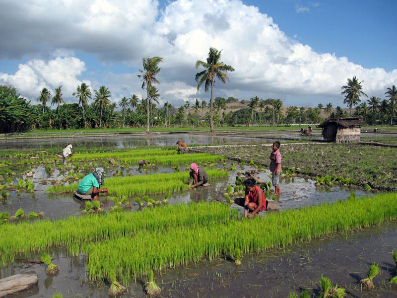


12 Mar
0
Pasola Horseback Fighting Festival Feb-March
Pasola is a game played by the Western Sumbanese to celebrate the rice planting season.
The game is played by throwing wooden spears to the opponent while riding a horse. The game is played by two different groups of men from different clans or tribes. It is a game that requires a high skill at horse riding and spear throwing skill.
It use to end up in a bloody game when the wooden spear hit the bare flesh of the participant. In the Sumbanese ancient beliefs, the spilled blood will fertilize the land and multiply the output of the paddy.
In the Wanukaka region, as part of the ritual, early in the morning the marapu priests and their entourage go the beach to perform a prayer. They sacrifice a black cock to the gods and check the heart of the cock to read the signs from the gods on whether to proceed with the pasola.
They descend to the sea afterwards to collect the colorful sea worm as part of the ritual, then proceed to the area where the game will be played.
Pasola is the name of ancient war ritual war festival by two groups of selected Sumbanese men. They riding their colorful decorated selected horses fling wooden spears at each other. This traditional ceremony held in the way of uniquely and sympathetically traditional norms, every year in February and March.
The festival occurs during February in Lamboya and Kodi. The main activity starts several days after the full moon and coincides with the yearly arrival to the shore of strange, and multihued sea worms – Nyale. The precise date of the event decided by Rato during the Wulapodu (the month of Pasola the fasting month).
Pasola is derived from the word Sola or Hola meaning a kind of a long wooden stick used as a spear to fling each other by two opponent groups of horsemen. The horses use for this ritual are usually ridden by braves and skilled selected men wearing traditional customs. In its wider and deeper meanings Pasola really not only is something worth looking on but also is something worth appreciating, for there are still other elements bound tightly behind it.
The people of Sumba believe that the ritual has a very close link to the habit of the people since it arranges the behavior and the habit of the people so that the balanced condition between the physical – material needs and the mental – spiritual needs can be easily created; or in other words the ritual is believed to be able to crystallize the habit and the opinion of the people so that they can live happily both in earth and in heaven. In addition to it, Pasola is also believed to have close relation to the activity in agriculture field, therefore any bloodshed (of sacrificial cattle or men participating in the game) is considered the symbol of prosperity that must exist. Without blood Pasola mean nothing to them. Those who died in the Pasola arena are believed to have broken law of tradition the fasting month.


21 Mar
0
Sumba Island Surfing Breaks Information
Being on Sumba you can experience one of the world’s more challenging surfing waves close to the hotel. Kerewe, Marosi and Dasang are beaches facing south in to the Indian Ocean and therefore the surf is very consistent.You will be a forerunner for those spots that still few people have discovered.
Located in the Lesser Sunda Island chain in Southeast Indonesia, just a hair east of Bali, Sumba is a beautiful island with a rich cultural tradition, and is home to world class waves. Not highly accessible, it’s not on everyone’s hit list. As with other surf destinations in Indonesia, it is blessed with great surf much of the year, particularly April through October.
WEST SUMBA SURFING
Nihiwatu Surf
Nihiwatu is a destination for surfers to bring their partners or families and do whatever they want in style and serious comfort. Nihiwatu is situated on one of the premier lefts in Indonesia, and the resort restricts the number of surfers booked into the resort to only 9 at any one time.
There is no doubt that Nihiwatu is one of the top waves in Indonesia and the world. The professional surfers who have visited Nihiwatu over the years have attested to this. There have been several surf movies made here with the arraignment of the owners and with the agreement that the filmmakers and photographers would not name the location.
Nevertheless the word has leaked out and now there is a cult following of surfers who know about Nihiwatu. In some circles Nihiwatu has already achieved legendary status.
Just 100 yards off of Nihiwatu beach is one of the world’s most perfect waves. Guests of ours have the added benefit of riding, or just watching, the incredible surf breaking on the reef directly in front of the resort.
Nihiwatu faces southwest into the Indian Ocean and is ideally suited for picking up swell arriving from thousands of miles away; the surf here is very consistent. If the surf is flat here you can be sure it is flat just about everywhere else in the archipelago.
Many professional surfers have visited Nihiwatu over the years and several surf movies have been filmed here featuring the 1999 world surfing champion Mark Occhilupo. If you are seeking large double overhead surf the best times are during the months of May through October on the full and new moons. In between those times we often have perfect waves in the three to six foot range.
The Waves and The Reefs
The wave breaks from deep water onto a shallow reef directly in front of the resort, tubing from start to finish. It is thick and steep on the takeoff and sucking a lot of water up the face. Nihiwatu is one of the fastest rideable waves anywhere, taking only six to ten seconds to travel the 250+ yard length of the wave.
This is not a hot dogging wave, it is full on down-the-line surfing. One slight mistake and you probably won’t make it to the channel. Nihiwatu breaks best at 4′ and above and the bigger the swell the better the wave becomes. 8′ to 10′ swells are common here and there are usually several 12’+ swells each year.
The coral reef is relatively surfer-friendly. The coral is pounded flat by the waves and hitting the bottom does not necessarily mean getting cut. In fact over the past twelve years there have been very few surfers with reef cuts and no serious injuries.
Access
The wave breaks 80 yards off the beach and ends in a deep channel. The setup is ideal and paddling out through the channel is easy without having to punch through the waves at all. If you do not make the wave the sweep of the water over the reef will push you back into the channel very quickly.
Tides
Tides in Indonesia change only about three feet during neap tides and up to 8 feet during the full and new moon periods. The wave at Nihiwatu has different personalities depending on the tide. At extreme high tide the wave is fuller and much easier to ride, perfect for surfers who are not accustomed to fast tubing waves. On extreme low tide, during the full and new moon periods, the wave breaks onto dry reef and is un-rideable except for the 50-yard end section. These extreme tide periods occur four days before and three days after the new and full moons. It is during these periods that surf can almost be guaranteed at Nihiwatu.
Typically the novice surfers go out at high tide with the accomplished surfers preferring to go out for the two to three hours of mid tides on either side of the peak high tide. That’s when its serious tube time at Nihiwatu. During the neap tides the change is minimal and does not affect the wave at all, one can surf all day on the high and low tides. These really are the optimum tides, providing there is swell.
Wind
Nihiwatu resort is protected from the prevailing crosswinds during the months of March to December. Unlike Bali, the trade winds do not blow day and night and for months on end. There can be periods of strong wind for four or five days then followed by very light wind conditions, even when it is blowing hard in other parts of Indonesia. Generally the peak winds will occur during the months of June, July and August although we have experienced a whole month of July with no strong winds at all.
When it is blowing hard the wave will be affected. Not by the wind on the wave, which is cross shore on the take off and offshore on the last half of the wave, but by a wind swell that comes from outside of the point and crosses the face of the wave during take off. It makes for tricky take offs, but once on the wave the face cleans up nicely and keeps tubing.
Even during the peak wind conditions the wind will be offshore in the morning before turning side shore by around 10am. During the worst conditions the wave will become blown out between 12:30 to 2 pm. This does not happen regularly but when it does then its time to try other activities like horseback riding on the beach, fishing and scuba diving, bird watching, mountain biking, trekking to a waterfall, relaxing at the pool or having a massage at the Jungle Spa.
SURF SPOT IN EAST SUMBA
The office
point break-like lefthander is the most consistent wave here. Works on all tides except max high and breaks eventually onto sand. Miles of beach break from here.
Racetrack
A wedgy left that accelerates and builds in size down the line , truly lives up to its name.
Five-O
Good lefthand barrel breaking along bend of reef into the main channel. It needs a six-foot swell to start breaking and is surfed at higher or dead low tide.
Manggudu Island waves
The island sits on the edge of very deep water and the waves can get very big. The western tip has a left and eastern a righthander. The left is a swell magnet with the dry season trade winds blowing offshore. Consistent overhead surf, bring a gun.
The left
The reef is large and the wave is best described as “sunset-like”. After peaking, it will bowl through hollow sections or just wall off right from the take-off, depending on swell direction. Can handle very big swell.
The Right
long wave that wraps all the way around the eastern tip of the island. Mellower wave than the left, but longer and hollower. Wet season wave, but you might get lucky on some mornings during the dry season before the winds come up.


